First above-normal Atlantic hurricane season since 2012 produced five landfalling U.S. storms

UPDATED: February 2, 2017. On February 1, 2017, the NOAA National Hurricane Center's Tropical Cyclone Report upgraded Otto to a major hurricane. To reflect this change, the Atlantic storm totals have been updated to 15 named storms, 7 hurricanes and 4 major hurricanes. On November 30, 2016, the Eastern Pacific storm totals were updated to 21 named storms, 11 hurricanes and 5 major hurricanes.

As the Atlantic, eastern Pacific and central Pacific 2016 hurricane seasons end today, NOAA scientists said that all three regions saw above-normal seasons.
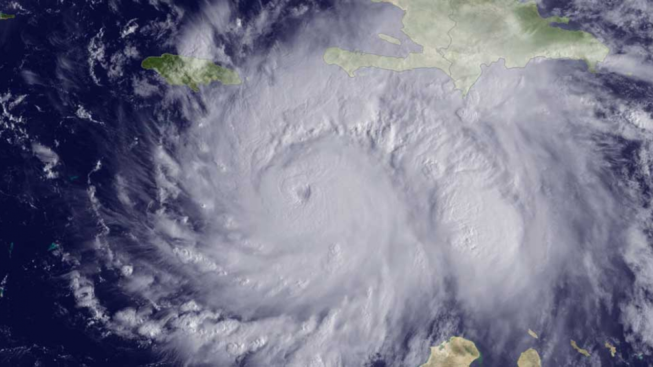
The GOES East satellite captured this image of Hurricane Matthew, currently located about 220 miles southeast of Kingston, Jamaica, at 1315 UTC on October 3, 2016.

The GOES East satellite captured this image of Hurricane Matthew, currently located about 220 miles southeast of Kingston, Jamaica, at 1315 UTC on October 3, 2016. (Image credit: NOAA)

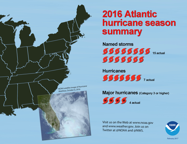
For the Atlantic, this was the first above-normal season since 2012. The Atlantic saw 15 named storms during 2016 including 7 hurricanes (Alex, Earl, Gaston, Hermine, Matthew, Nicole and Otto), 4 of which were major hurricanes (Gaston, Matthew, Nicole and Otto). NOAA’s updated hurricane season outlook in August called for 12 to 17 named storms, including 5 to 8 hurricanes, with 2 to 4 of those predicted to become major hurricanes.

Five named storms made landfall in the United States during 2016, the most since 2008 when six storms struck. Tropical Storm Bonnie and Hurricane Matthew struck South Carolina. Tropical Storms Colin and Julia, as well as Hurricane Hermine, made landfall in Florida. Hermine was the first hurricane to make landfall in Florida since Wilma in 2005.

Several Atlantic storms  made landfall outside of the United States during 2016: Tropical Storm Danielle in Mexico, Hurricane Earl in Belize, Hurricane Matthew in Haiti, Cuba, and the Bahamas, and Hurricane Otto in Nicaragua.

The strongest and longest-lived storm of the season was Matthew, which reached maximum sustained surface winds of 160 miles per hour and lasted as a major hurricane for eight days from Sept. 30 to Oct. 7. Matthew was the first category 5 hurricane in the Atlantic basin since Felix in 2007.

2016 Atlantic hurricane season summary (Updated: February 2017).
2016 Atlantic hurricane season summary (Updated: February 2017). (NOAA)

Matthew intensified into a major hurricane on Sept. 30 over the Caribbean Sea, making it the first major hurricane in that region since Poloma in 2008. It made landfall as a category 4 major hurricane in Haiti, Cuba and the Bahamas, causing extensive damage and loss of life. It then made landfall on Oct. 8 as a category 1 hurricane in the U.S. near McClellanville, South Carolina.

Matthew caused storm surge and beach erosion from Florida through North Carolina, and produced more than 10 inches of rain resulting in extensive freshwater flooding over much of the eastern Carolinas. The storm was responsible for the greatest U.S. loss of life due to inland flooding from a tropical system since torrential rains from Hurricane Floyd caused widespread and historic flooding in eastern North Carolina in 1999.

“The strength of Hurricane Matthew, as well as the increased number of U.S. landfalling storms this season, were linked to large areas of exceptionally weak vertical wind shear that resulted from a persistent ridge of high pressure in the middle and upper atmosphere over Caribbean Sea and the western Atlantic Ocean,” said Gerry Bell, Ph.D., lead seasonal hurricane forecaster at NOAA’s Climate Prediction Center. “These conditions, along with very warm Caribbean waters, helped fuel Matthew’s rapid strengthening.”
 

Eastern and central Pacific Hurricane Seasons

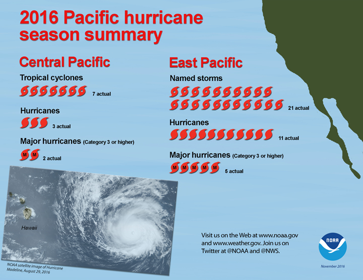
Eastern and central Pacific Hurricane Seasons, 2016 Summary
Credit: NOAA


The eastern Pacific hurricane basin, which covers the eastern Pacific Ocean east of 140 degrees West, produced 21 named storms during 2016, including 11 hurricanes of which 5 became major hurricanes. July through September was the most active three-month period on record for this basin. NOAA’s eastern Pacific hurricane season outlook called for 13 to 20 named storms, including 6 to 11 hurricanes, 3 to 6 of which were expected to become major hurricanes.

The central Pacific hurricane basin covers the Pacific Ocean west of 140 degrees West to the International Date Line. This basin saw seven tropical cyclones (includes tropical depressions and named storms) during 2016. All seven became named storms, and included three hurricanes of which two were major hurricanes. Tropical Storm Darby made landfall on the Big Island of Hawaii, marking the first time in recorded history that two storms in three years struck the Big Island (Darby in 2016 and Iselle in 2014). NOAA’s central Pacific hurricane season outlook called for 4 to 7 tropical cyclones. That outlook does not predict specific ranges of named storms, hurricanes and major hurricanes.

Contact:
Susan Buchanan, 3
01-427-9000​
Dr. Gerry Bell, NOAA lead seasonal hurricane forecaster