Summer 2018 ranked 4th hottest on record for U.S.

In a tie with 1934, the Summer of 2018 ranked as the fourth hottest summer on record for the contiguous United States after three months of blistering temperatures. August 2018, meanwhile, finished as the 17th warmest August, as the Southwest and Northeast broiled under record heat.

A NOAA satellite image of Hurricane Lane as it approached the Hawaiian Islands on August 22, 2018. The storm brought massive flooding and extreme rainfall to parts of Hawaii.

A NOAA satellite image of Hurricane Lane as it approached the Hawaiian Islands on August 22, 2018. The storm brought massive flooding and extreme rainfall to parts of Hawaii. (Image credit: NOAA Satellites)

Let’s take a closer look at highlights from NOAA’s latest U.S. climate analysis:

Climate by the numbers

August 2018

The average August temperature across the contiguous U.S. was 73.6 degrees F (1.5 degrees above average), making it the 17th-warmest August in the 124-year record, according to NOAA’s National Centers for Environmental Information (NCEI).

Parts of the Southwest had temperatures in the top 10 for warmth, while several Northeast states experienced record heat, largely due to record-warm overnight temperatures.  

The average precipitation for August was 2.99 inches (0.37 inch above average), making it the 20th wettest August on record, tied with 1979 and 2005. Areas from the Great Plains to the East Coast had above-average precipitation thanks to slow-moving storm systems that dropped heavy rain. The Mid-Atlantic region saw record precipitation.

Year to date | Meteorological summer

During the meteorological summer (June through August), the average temperature for the contiguous U.S. was 73.5 degrees F, 2.1 degrees above average. In fact, both 2018 and 1934 hold the record for having had the fourth warmest summer.

The average U.S. temperature for the year to date (January through August) was 55.7 degrees F, 1.8 degrees above normal. It was the 10th warmest YTD on record with an above-average precipitation total of 21.67 inches (0.96 of an inch above average).

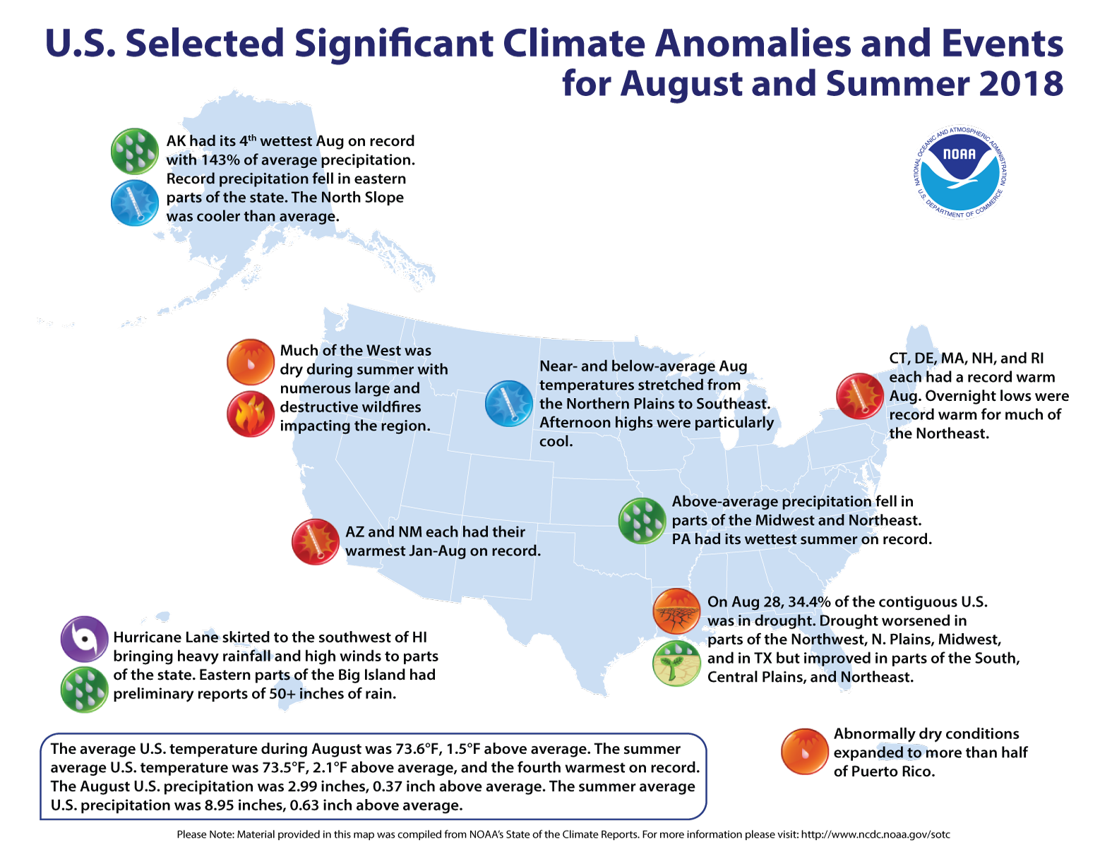
An annotated map of the United States showing notable climate events that occurred in August and Summer 2018. For details, see the bulleted list below in our story and online at http://bit.ly/USClimate201808.
An annotated map of the United States showing notable climate events that occurred in August and Summer 2018. For details, see the bulleted list below in our story and online at http://bit.ly/USClimate201808. (NOAA NCEI)

More notable climate events

  • No beating the heat: Twenty-three states across the West, South and Northeast had much-above-average summer temperatures. The average overnight low summer temperature for the contiguous U.S. was 60.9 degrees F (2.5 degrees above average and 0.1 degree hotter than the previous record in 2016.)

  • Hurricane Lane drenched Hawaii: Lane brought massive flooding and extreme rainfall (preliminary reports of more than 50 inches in places) to parts of the Hawaiian Islands.  

  • Drought increased slightly: August ended with 34.4 percent of the contiguous U.S. in drought, up from 34.1 percent in July.  

Access NOAA’s report and download images from the NCEI website.

Media contact

John Leslie, 301-713-0214