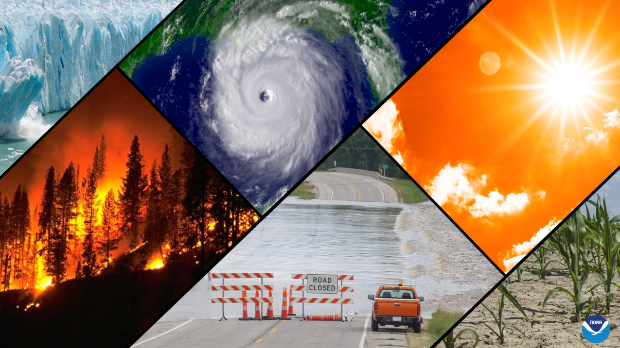
A collage of typical climate and weather-related events: floods, heatwaves, drought, hurricanes, wildfires and loss of glacial ice. (Image credit: NOAA)
As the lead federal climate science agency, NOAA delivers research, data, services and solutions to help communities, tribes, federal, state and local agencies and the international community understand, mitigate, prepare for and build resilience to climate change.
NOAA is dedicated to building a Climate-Ready Nation, where prosperity, health, safety and continued growth benefit from a shared understanding of and collective action on climate change.
Understanding climate change
Weather refers to the short-term state of the atmosphere. It is the answer to questions like: “Will it be rainy, sunny or windy tomorrow?” or “What’s the temperature like outside right now?” Climate refers to long-term patterns of weather conditions. The answer to questions like “How hot is it in June in Arizona?” or “How much snow usually falls in Buffalo?” In short, climate is what you expect. Weather is what you get. Climate change refers to changes to these long-term patterns.
While Earth’s climate has changed naturally many times during its 4.6 billion year lifetime due to causes like changes in the sun’s energy, the earth’s orbit, ocean currents or volcanic activity, none of those natural factors are the cause of today’s rapid changes to our climate. Instead, it is unequivocal that human influence offsite link has warmed the atmosphere, ocean and land, primarily through the release of heat-trapping gases from the burning of fossil fuels. This, in turn, has made sea levels rise, the ocean to become more acidic, and extreme climate events, including heatwaves, heavy rainfall, and droughts, more frequent and severe.
In fact, there is a greater than 99-percent consensus offsite link on human-caused climate change in peer-reviewed scientific literature. And virtually all climate scientists agree that, since the late 19th century, the rise of heat-trapping gases from human activity, such as carbon dioxide, is causing global average temperatures to increase.
According to the sixth assessment report of the Intergovernmental Panel on Climate Change offsite link, it is likely that almost all of the warming observed since the late 19th century – around 2°F (1.09°C) – is due to human activities. And that human influence has warmed the climate at a rate that is unprecedented in at least the last 2,000 years.
In addition to carbon dioxide, methane and nitrous oxide play a significant role in regulating the temperature of the planet. These greenhouse gases absorb heat radiated by the sun-warmed surface of the ocean and land, trapping that heat before it can escape into space.
The levels of atmospheric carbon dioxide offsite link are higher currently than at any time in at least two million years, while methane and nitrous oxide levels are the highest they have been in at least 800,000 years. This human-caused rate of increase since 1750 in carbon dioxide and methane far exceeds the natural, multi-thousand year rate of increase between glacial and interglacial periods over the last 800,000 years.
Human-caused climate change is already affecting nearly every part of the planet, in multiple ways. And the changes we experience will increase with further warming. To limit global warming, strong, rapid and sustained reductions in carbon dioxide, methane and other heat-trapping gases are necessary.
Climate data and statistics
Climate.gov provides a Global Climate Dashboard that shows changes in temperature, sea level rise, ocean heat, snowfall, greenhouse gases and other indicators over time.
NOAA’s National Centers for Environmental Information’s (NCEI) State of the Climate provides a monthly recap of climate-related events on national and global scales, tracking how heavier downpours, drought, severe storms and more impact a wide range of weather.
NOAA’s NCEI manages and maintains the nation’s database for historical weather and climate information on local to global scales. NCEI offers the Climate at a Glance tool, which provides access to one of the most substantial public environmental data archives in the world.
Heat.gov provides a go-to source for heat and health information, designed to reduce the health, economic and infrastructural impacts of extreme heat. Heat is the deadliest weather-related hazard in the U.S.
Drought.gov is a one-stop shop for data, decision-support products, resources and information on drought, including tools to view current and future drought at the state and county level.
NOAA’s National Ocean Service produces regular updates on global sea level and national trends for high-tide flooding.
Global sea level has been rising over the past century, an estimated 8-9 inches since 1880, and the rate has more than doubled in recent decades. The rising levels are primarily driven by a combination of melting water from glaciers and ice sheets and thermal expansion of seawater as it warms. The accelerating rate over recent decades is due mostly to increased ice sheet melt. Higher sea levels mean that deadly and destructive storm surge pushes farther inland, and there is more frequent high-tide flooding.
For the latest sea level rise projections through 2150, see the 2022 Sea Level Rise Technical Report and NOAA’s companion guide to help coastal communities plan for significant sea level rise. NOAA’s Digital Coast provides data, tools and training to help coastal communities prepare and adapt to impacts from sea level rise.
Research and monitoring
Scientists at NOAA have long worked to track, understand and predict how climate change is progressing and affecting communities, ecosystems and economies. NOAA keeps accurate, up-to-date measurements of greenhouse gases in the Earth’s atmosphere through a network of observatories and sampling sites. NOAA also studies how complex interactions between natural and human-caused emissions and atmospheric dynamics affect climate.
NOAA is investigating how to improve seasonal weather forecasting, from severe weather (tornadoes), to how changing climate will affect weather events, such as flooding and drought. High-impact weather events are increasing, with 2022 producing 18 disasters each causing one billion+ dollars of damage in the U.S. and a cumulative annual cost of $165 billion.
More than 90 percent of Earth’s warming over the past 50 years has occurred in the ocean. To track ocean variables, NOAA maintains the world’s largest real-time marine observation network – 1,300 weather observing stations – and works with partners to collect ocean observations using a variety of tools, including buoys, free-floating gliders, Argo floats, saildrones and more. Observations are used in climate and weather prediction models to help understand how the changing ocean affects climate and the environment.
In the Great Lakes, NOAA works with partners to monitor temperatures and study environmental changes. NOAA scientists monitor and provide predictions for Great Lakes yearly ice cover and harmful algal blooms.
The Arctic is warming more than twice as fast as anywhere else on Earth, and NOAA supports a wide range of research activities in the Arctic. Each December, NOAA issues an annual Arctic Report Card focusing on how the Arctic environment is changing.
Modeling and prediction
Climate models are vital tools for improving the understanding and predictability of climate. Models investigate the degree to which observed climate changes may be due to natural variability, human activity or both. Their projections provide essential information to better inform decisions on water resource management, agriculture, transportation, community heat resilience planning and much more. NOAA’s global climate models support national and international climate assessments.
A world leader in climate model development and research, NOAA’s Geophysical Fluid Dynamics Laboratory advances experimental models that have a long history of helping improve weather and climate forecasting.
NOAA produces temperature and precipitation outlooks that predict temperatures and precipitation forecasts ranging from six days to three months to help communities prepare for what is likely to come and to minimize weather’s impacts on lives and livelihoods. NOAA also produces drought and El Niño/La Niña outlooks to help communities, businesses and the public plan ahead.
Preparedness and adaptation
Climate resilience is the ability of individuals, communities, businesses and governments to prepare for and adapt to the impacts of climate change, such as sea level rise, flooding and extreme heat. NOAA experts work with communities across the country to develop the data, information and strategies needed to prepare for and adapt to climate change impacts.
NOAA Climate Program Office’s Climate and Societal Interactions (CSI) division funds research, develops tools and knowledge, and builds capacity and partnerships through the Climate Adaptation Partnerships (CAP) and the Adaptation Sciences (AdSci) Program to enhance society’s capacity to anticipate, plan for and adapt to climate impacts.
Climate.gov and the U.S. Climate Resilience Toolkit provide case studies on how local communities and regions are building resilience and adapting to climate change, the Climate Explorer offsite linkwhich helps users access observed and projected climate trends for every county in the country, as well as over 500 digital tools including maps, data, videos and updates on climate impacts.
NOAA’s Office for Coastal Management has two state partnership programs (coastal zone management and national estuarine research reserves) on the forefront of efforts to apply the best available science to climate-related issues on a local level. The office also houses the Digital Coast, an online platform for relevant data, tools and training. The site’s climate adaptation page provides specific links to the myriad of resources available.
The NOAA Sea Grant program works with communities to increase resilience to climate change, bringing together experts and community leaders for planning offsite link, assisting with green infrastructure projects offsite link, coastal shoreline adaptation, marine debris removal, outreach and education. Additionally, Sea Grant's hazard preparedness resources offer coastal residents and homeowners easy-to-read information on risks in their area and instructions to mitigate these risks.
Fisheries and Marine Life
Climate change has significant impacts on the nation’s valuable marine life, fisheries, vital coastal habitats and the many communities and economies that depend on them. Scientists expect environmental changes, such as warming oceans, rising sea levels and the frequency and intensity of floods, droughts and ocean acidification to increase with climate change.
NOAA Fisheries’ Climate Science Strategy, Regional Climate Action Plans, Ecosystem-based Fisheries Management Road Map and National Marine Ecosystem Status website help scientists, fishing groups, managers and businesses better understand the changes occurring and the actions needed to safeguard America’s marine life and resource-dependent communities. NOAA is building a decision support system to assist communities adapt to the unique climate impacts in their regions.
Equity and Climate
NOAA supports equitable climate resilience through projects that focus on community involvement, equity and environmental justice. These recent pilot projects grew out of climate roundtables held around the country by NOAA to gather feedback from community partners to inform how NOAA provides climate services, engages with underserved and vulnerable communities and strengthens the processes to respond to expressed needs. Equity is also at the heart of the seven-year-old program to address urban heat islands that affect the health of communities across the nation. NOAA works with communities to help them map their hottest neighborhoods. These maps and information are then used by communities to plan and put in place cooling solutions strategies. Learn more about NOAA’s environmental justice efforts.
More visual tools to understand climate change
Climate Mapping for Resilience and Adaptation is a new tool that gives communities across the nation real-time information about climate change-related hazards in their area and helps communities identify federal funds for climate resilience projects.
Building a Climate-Ready Nation offsite link is a story map that shows how NOAA and our partners are tackling resilience on five issues: heat, drought, wildfires, rising tides and marine species.
Science on a Sphere illustrates Earth science by projecting compelling visualizations onto a giant sphere, telling the story of temperature change, sea level rise and more in a fresh and innovative way.
Ocean Today videos offer a range of climate-related titles, featuring wild weather, dead zones, hurricanes, ocean conservation, Arctic harbingers of climate change and more. Videos on multiple other topics and footage for media are available.
The Sea Level Rise Viewer animates sea level rise on the local level and generates potential scenarios to factor into planning for community resilience. A similar tool, the Lake Level Viewer, serves communities bordering the Great Lakes.
Additional climate resources
For more on climate change’s connection to extreme weather events, see the following topic-specific NOAA media resource guides:
- Drought media resource guide
- Extreme heat media resource guide
- Hurricane season media resource guide
- Wildfire season and fire weather media resource guide
Media contact
Monica Allen, monica.allen@noaa.gov, (202) 379-6693


