
Overview
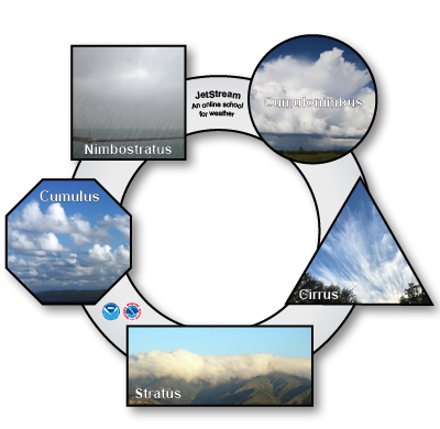
Cloud names originate from four major cloud forms: cirro-form, strato-form, cumulo-form and nimbo-form. The first three directly identify specific clouds. The fourth type, nimbo, means rain and is a part of two other cloud types.
| TOTAL TIME | 10 minutes for each observation. |
|---|---|
| SUPPLIES | Scissors; Tape or glue |
| PRINTED/AV MATERIAL | 'Hole' Lot of Clouds 1 disc and images for each student. Cloud symbols for classroom discussion. |
| TEACHER PREPARATION |
If possible, plan this lesson within four days of an upcoming cold front. This will help maximize the variety of clouds the students will observe. Optional: Access to NOAA Cloudwise Chart and/or the Cloud Classification page via the Internet. |
| SAFETY FOCUS | Thunderstorm Safety |
Procedure
- Have the students cut the disc out along the thick/solid black lines followed by the shapes that contain the images of clouds. Note: There are two sets of images, one with cloud names and the other with descriptive terms. You decide which version to use (or you can use both).
- Glue or tape cloud images into their respective locations by matching shapes with dashed lines on the disc. As an option, you can attach both name and descriptive terms by matching shapes on opposite sides of the disc so that one side has scientific names and the other uses descriptive terms.
- Hold the disc up into the sky and peer through the hole at the clouds.
- Returning to the classroom, attach cloud symbols to a wall, and have students discuss what types of cloud(s) were observed and the justification for their conclusions.
Discussion
Distinguishing between cloud types can be difficult. The following should help discern some of the differences.
- Cumulus is Latin for "heap" or "pile". These are the "puffy" clouds that look like cotton balls heaped on top of each other and rise vertically.
- Stratus is Latin for "layered" or "flat". There may be some hints of "puffiness" to the cloud, but their appearance is, for the most part, flat and in a single layer.
- Cirrus is Latin for a "lock of hair" and are high level clouds consisting of ice crystals. This is the reason for the "wispy" appearance that is often seen.
- Nimbus is Latin for "rain". Nimbus is not a distinct cloud but a part of two cloud types from which the vast majority of precipitation falls.
- Precipitation (rain/sleet/snow) falling in a steady or slowly changing intensely comes from nimbostratus (nimbus plus stratus). Nimbostratus is a gray nebulous layered cloud where precipitation is not apparent off in the distance.
- Precipitation intensity that changes rapidly (or begins/end abruptly), called "showers", comes from very tall cumulus clouds. If accompanied by lighting, then the cloud is always a cumulonimbus (cumulus plus Nimbus). Precipitation from cumulus/cumulonimbus clouds are often readily visible off in the distance.
There may be a variety of responses from students viewing the same cloud as similarities exists between different cloud types. This is because while cumulus, stratus, and cirrus are distinct clouds in and of themselves, these names are then combined to comprise the rest of the list in the basic ten clouds.
For example, cirrostratus comes from cirrus plus stratus. Cirrostratus is a wispy looking cloud but can be thick enough to partially block sunlight and also have a flat layered appearance.
Stratocumulus comes from cumulus plus stratus. Stratocumulus clouds can have some rounded definitions, like cumulus, though these rounded mounds are not nearly as sharp are generally flat with little vertical development.
Building a Weather-Ready Nation
Studies have shown most people struck by lightning are struck not at the height of a thunderstorm but before and after the storm has peaked. This is because many people are unaware that lightning can strike as far as 25 miles (40 km) from the area where it is raining.
Therefore, if you can hear thunder, you are within striking distance. Seek safe shelter immediately. Remember this lightning safety rule...When thunder roars, go indoors and stay there until 30 minutes after the last clap of thunder. DO NOT wait for the rain to start before seeking shelter, and do not leave shelter just because the rain has ended.
With knowledge, you can greatly increase your safety and the safety of those you are with. At the first clap of thunder, go to a large building or fully enclosed vehicle and wait 30 minutes after the last clap of thunder before you to go back outside.


