
Since earthquakes are responsible for almost 90% of the tsunamis on record, it is useful to better understand earthquakes and the forces that cause them. Doing this requires looking into Earth's construction.
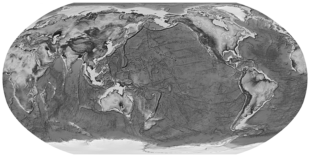
Earth's interior is made up of layers. Scientists define these layers in two ways. Most widely known are the three main layers defined by their chemical and physical makeup: the crust, mantle, and core.
The other way Earth's layers are defined has to do with how they respond to pressure and temperature changes (basically, how they move). These are the lithosphere, asthenosphere, mesosphere, and core.
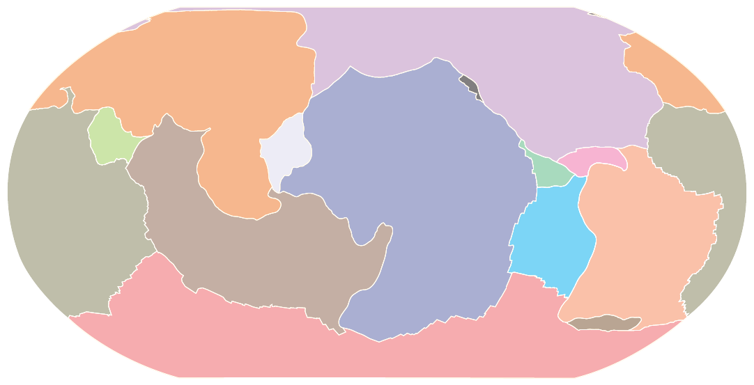
Together, the crust and the upper part of the mantle form the lithosphere, Earth's solid outer shell. This rocky, brittle layer is broken up into seven major and several minor tectonic plates (also known as lithospheric plates) that fit together like puzzle pieces.
")
These plates are in constant motion. They can move at rates of up to four inches (10 centimeters) per year, but most move much slower than that. Different parts of a plate move at different speeds. The plates move in different directions, colliding, moving away from, and sliding past one another.
Most plates are made of both oceanic and continental crust. An exception is the Pacific plate, which is nearly all oceanic crust. Oceanic crust (basaltic) is thinner and denser than thick and buoyant continental (granitic) crust.
Because of their differences in movement and makeup, the plates interact with each other in various ways. These interactions take place at plate boundaries.
Plate tectonics is the scientific theory that describes how the plates move, behave, and shape our landscape.
Plate Boundaries
There are three types of plate boundaries, defined based on how the plates move relative to each other (i.e., collide with, move away from, slide past). In addition, each type of boundary is associated with particular geologic activities, like earthquakes and the creation of mountains and volcanoes. Most earthquake and volcanic activity occurs along or near plate boundaries.
This interactive map shows tectonic plates and their motion at various points (in millimeters per year) relative to the African plate. Click through the options below to learn more.


At convergent boundaries, plates are colliding and unleashing great geological forces, like large earthquakes and explosive volcanoes. As they collide, the edge of one or both plates may be forced up into a rugged mountain range, like the Himalayas, which formed at the boundary of the Eurasian and Indian plates (the Indian plate is now part of the Indo-Australian plate). If one of the plates is topped with oceanic crust, it is forced (subducted) under the lighter plate, creating a subduction zone.
Subduction zones are where the world's largest earthquakes, powerful tsunamis, explosive volcanoes, and massive landslides happen. These zones are marked by deep ocean trenches and chains of volcanic mountain ranges or island arcs that form parallel to the plate boundaries. An example of this kind of convergence is happening at the Cascadia subduction zone off the coast of the Pacific Northwest.

At divergent boundaries, plates are moving away from each other. Volcanic activity and earthquakes occur at divergent boundaries, but they are not as violent as those at convergent boundaries.
Where plates diverge below the ocean, magma (molten rock) rises from the mantle to fill the space between the plates and solidifies, forming underwater mountain ranges called mid-ocean ridges. The largest ridge is the Mid-Atlantic ridge, where the North and South American plates diverge from the Eurasian and African plates.
On land, rift valleys form where plates diverge. A good example of this is the East African rift valley.
At transform boundaries, plates are sliding past each other horizontally in different directions. Transform boundaries can produce great earthquakes, but volcanoes are rare. A well known example of a transform boundary is the San Andreas fault, which separates the North American plate from the Pacific plate and is responsible for many of California's earthquakes.
Faults and Earthquakes


As the plates move, their rough edges can get stuck on each other. This stops movement at the boundary while the rest of the plates keep moving.
Stress builds up, and when it becomes too much, the plates suddenly slip past one another, and the rocky, brittle lithosphere cracks. These cracks are called faults. It is the energy released by the sudden movement on these faults that causes most earthquakes.
Plate boundaries are made up of many faults. How plates move relative to each other determines, in part, the type of faults at their boundaries. There are three basic types of faults: reverse (or thrust), normal, and strike-slip. Earthquakes are often described based on the type of fault they occur on.
- Reverse (or thrust) earthquakes are caused by slip along a gently sloping fault where the rock above the fault is pushed up relative to the rock below. They commonly occur at convergent boundaries. Most tsunamis, and the largest, result from reverse earthquakes. View a reverse fault animation from the U.S. Geological Survey.
- Normal earthquakes are caused by slip along a sloping fault where the rock above the fault moves down relative to the rock below. They frequently occur at divergent boundaries. View a normal fault animation from the U.S. Geological Survey.
- Strike-slip earthquakes are caused by horizontal slip along a fault. They frequently occur at transform boundaries. View a strike-slip fault animation from the U.S. Geological Survey.
However, earthquakes are not typically so simple. It is common for fault movements to include both up-and-down and side-by-side movement together.
In addition, not all earthquakes occur at plate boundaries. Faults located far from plate boundaries also generate earthquakes, but less frequently, and they are difficult to explain.
Measuring Earthquakes
")
Seismic stations contain instruments that detect, measure, record, and transmit information about the shaking caused by an earthquake (the seismic waves). Scientists rely on networks of seismic stations to determine the location and size of an earthquake.
Magnitude is the most common way to describe earthquake size. It is a measure of the energy released by an earthquake. It is the same no matter where you are and what the shaking feels like.
Earthquakes with large magnitudes typically last longer and release their energy over larger areas than those with smaller magnitudes. There are many ways to determine earthquake magnitude, but the U.S. tsunami warning centers use the moment magnitude scale, an extension of the original Richter magnitude scale, because it provides the most accurate measurements for the large earthquakes that can cause tsunamis.
Magnitude is complicated, but it is important to understand that for large earthquakes, minor increases in magnitude result in huge jumps in released energy.
With each whole number increase in magnitude, the energy release increases about 32 times. And with the increase of two whole numbers, the energy release increases about 1,000 times. For example, a magnitude 8.0 earthquake releases about 32 times more energy than a magnitude 7.0 earthquake and 1,000 times more energy than a magnitude 6.0 earthquake.
")
The December 26, 2004, earthquake in the Indian Ocean had a magnitude of 9.1. Three months later, on March 28, 2005, a magnitude 8.7 earthquake occurred on the same fault line as the December event. Despite the small numerical difference in magnitude (just 0.4), the December earthquake released four times more energy than the March earthquake.
You may find it easier to understand another measurement of earthquake size - its intensity. Intensity is based on the observed effects of an earthquake's shaking (e.g., ground shaking and damage) and is measured using the Modified Mercalli Intensity scale.
This scale features increasing levels of intensity (effects) and ranges from not felt to total damage. Unlike magnitude, intensity varies with location. (Since intensity values are assigned after an earthquake, they do not support the real-time needs of tsunami warning centers.)

Earthquakes are not unusual. According to the U.S. Geological Survey, there are an estimated 500,000 detectable earthquakes in the world each year. 100,000 of those can be felt, and 100 of them cause damage.
Magnitude 2.0 and smaller earthquakes, which may not even be felt, occur several hundred times a day. On average, earthquakes greater than magnitude 7.0 happen more than once a month, and earthquakes greater than magnitude 8.0 happen about once a year.
Did you feel an earthquake? Report it on the U.S. Geological Survey's "Did You Feel It" website.
More about Plate Tectonics and Earthquakes
- Earthquake Lists, Maps, and Statistics (U.S. Geological Survey)
- Earthquake Safety (Federal Emergency Management Agency)
- This Dynamic Earth: The Story of Plate Tectonics (U.S. Geological Survey)
- U.S. Geological Survey's Earthquake Hazards Program (U.S. Geological Survey)