During 2012, the network of WSR-88Ds was upgraded to dual polarization.
The electric field of a transmitted pulse of energy oscillates, or moves back and forth; polarization refers to looking at just one plane or direction in which the electric field oscillates. It is an important aspect of any radar, as it determines what kinds of targets are best identified.
For instance, weather radars are usually polarized in the linear horizontal plane. Since drops of liquid tend to flatten out as they fall, this horizontal polarization is excellent at striking the falling rain and returning data back to the radar. Air traffic control radars meanwhile are interested in detecting aircraft, not precipitation, so these radars are often polarized in a circular configuration to avoid detecting rain.
Before the upgrade, all WSR-88Ds were polarized in a linear horizontal configuration. After the upgrade, the radars have the ability to receive target information in both the horizontal and vertical planes. The upgrade to dual polarization allows meteorologists to obtain information about the size and shape of targets that are detected. This is important as it significantly improves the detection of heavy rainfall and can aid in the detection of large hail and debris. Transitions in precipitation type, for example from rain to snow or from rain to sleet, are also much easier to identify with dual polarization. There are three additional base products that are now available after the upgrade to dual polarization. They are Differential Reflectivity, Correlation Coefficient, and Specific Differential Phase. We’ll briefly take a look at each of these products and highlight their utility to forecasters.
Differential Reflectivity (ZDR)
In order to detect precipitation a long distance from the radar, Base Reflectivity (Z) uses information from the horizontal channel since rain tends to flatten out as it falls, as described above. This maximizes the returned power back to the radar. However, the radar also receives information in the vertical channel. Differential Reflectivity (ZDR) is simply a power comparison between the horizontal channel and the vertical channel. The units of ZDR are in decibels (dB).
ZDR = ZH - ZV
Differential reflectivity is simply the power difference between the horizontal channel and the vertical channel. This information can be used to determine the shape of the dominant precipitation targets. Let’s take a look!

In the above image we have three different precipitation shapes. The first one is round, similar to a sleet pellet, small piece of hail, or small water droplet. Since the shape is round, it will return about as much power in the horizontal as it will in the vertical. In this case, the ZDR would be near 0 dB. In the middle image, the precipitation is flattened, similar to a large raindrop that falls. Because it’s flatter in the middle, it will return more power in the horizontal than it will in the vertical. In this case, the ZDR will be greater than 0 dB. In the image on the right, the precipitation is needle-like, similar to a falling ice crystal or elongated snowflake. Because it’s oriented vertically, it will return more power in the vertical than it will in the horizontal. In this case, the ZDR will be less than 0 dB.
So what does this look like in the real world? Let’s take a look at a few examples:
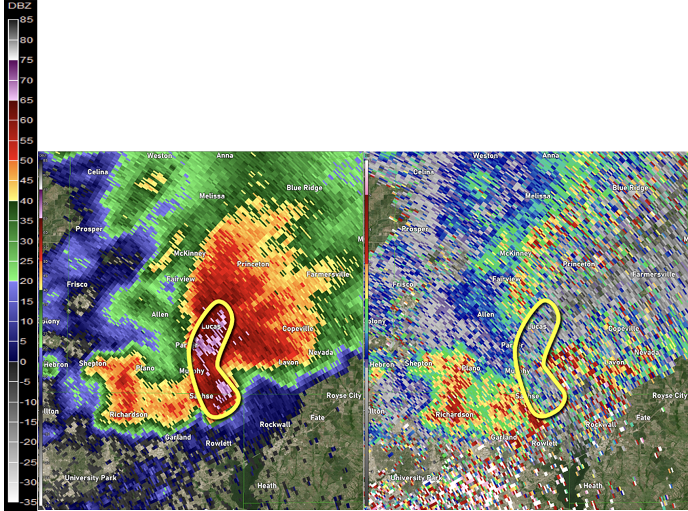
In the above image, the ZDR is near 0 dB. Based on our chart above, this is an indication of large hail, as hail tends to tumble as it falls. Because it tumbles, it appears spherical to the radar and therefore returns about the same amount of power in the horizontal direction as in the vertical direction. This was a devastating hail storm, producing multiple 5-inch diameter hail stones and causing more than $1 billion in damage.
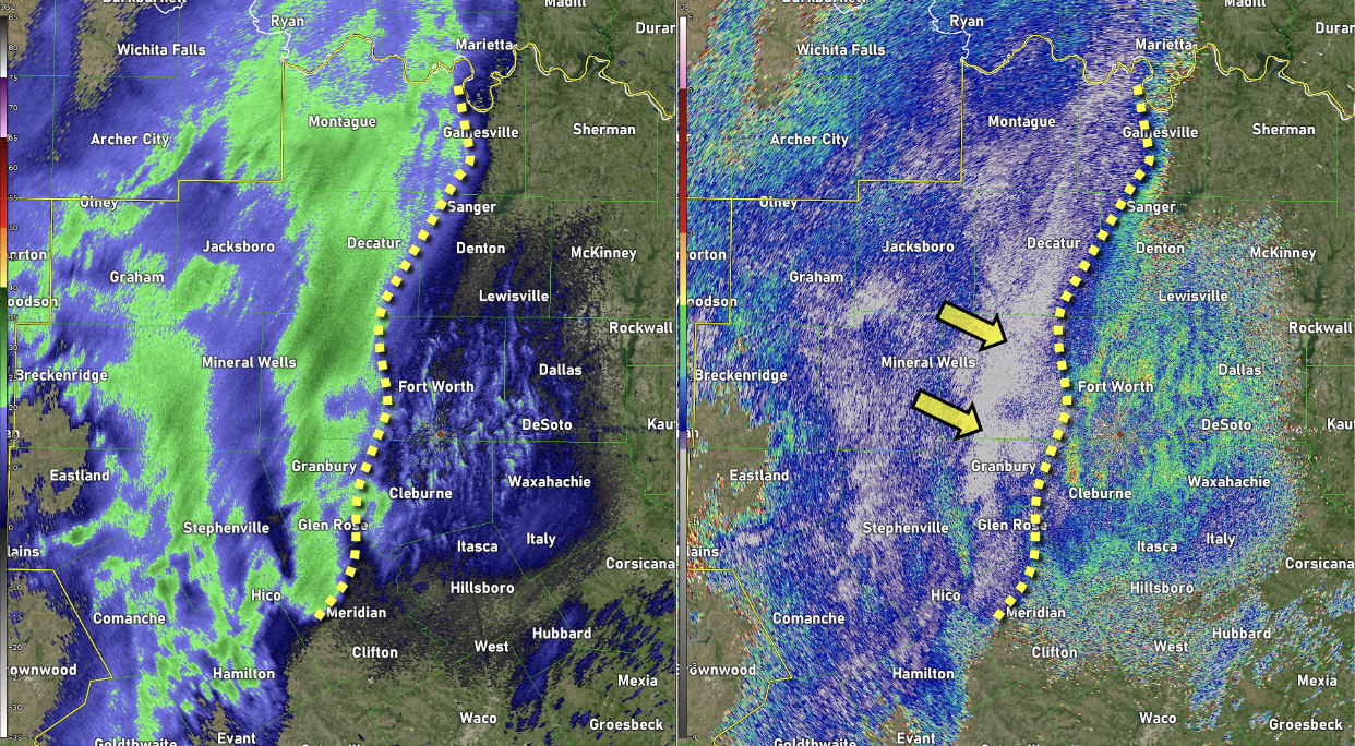
In the above image, a precipitation transition is occurring near the dashed yellow line. To the east (right) of this line in the very light spotty reflectivity, notice the ZDR is much greater than 0 dB, indicating flatter drops. In this area, light rain was occurring. To the west (left) of the line, near the arrows, the ZDR is near or less than 0 dB. This is mostly snow. While it’s difficult to identify the transition line using just the reflectivity image, the transition is very clear when looking at the differential reflectivity.
Correlation Coefficient (CC)
Of the three dual polarization base products, correlation coefficient (CC) is likely to be the most used, and may even be shown on television at times. Correlation coefficient is a measure of how similar the horizontal and vertical pulses behave after hitting a target. If the pulse to pulse change is similar between horizontal and vertical, then CC will be high. If the pulse to pulse change is highly variable, then CC will be low. Essentially, Correlation Coefficient shows how similar the targets are that are being sampled. CC can be used with Differential Reflectivity to identify areas of precipitation transition, such as a rain/snow mix, because the values will be lower in these areas compared to areas that have all rain or all snow. CC is a unitless measure and ranges from 0 to 1. Let’s take a closer look!
|
Non Meteorological
|
Non-Uniform Meteorological
|
Uniform Meteorological
|

|
Low CC |
Moderate CC |
High CC |
Correlation Coefficient and the Tornado Debris Signature (TDS)
Over the years, one of the more interesting uses for correlation coefficient has been in the detection of tornadoes. When tornadoes loft debris into the air, the radar samples these objects and sends information back to the receiver. The size and shape of debris is highly variable, which causes a high variability in the pulse to pulse change between horizontal and vertical returns. Because of this, CC drops significantly. A Tornado Debris Signature is defined as a significant drop in correlation coefficient which is co-located with a strong rotational couplet in the velocity data. Let’s take a look!
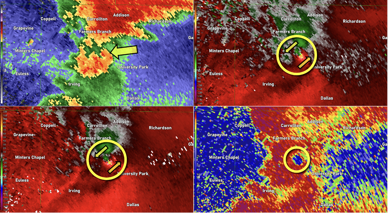
In the above image, a tornado is in progress and can be confirmed by radar because of the significant drop in correlation coefficient. This drop in CC must be co-located with a strong velocity couplet in order to be classified as a tornado debris signature. If they are not co-located, then a tornado cannot be confirmed. Let’s take a look at another case!
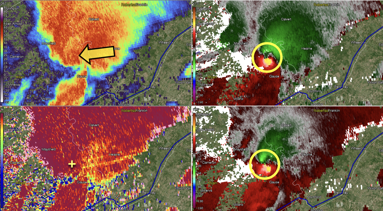
In the above image, we can see that the tornado debris signature will not always be evident. There was a large tornado in progress at the time of this image, but no drop in CC. A drop in CC will only occur if debris is lofted high enough to be sampled by the radar. While CC can be used to confirm a tornado, it does not predict tornadoes before they occur.
Specific Differential Phase (KDP)
Specific Differential Phase is similar to Differential Reflectivity in that it is dependent upon the shape of the targets that are hit. Instead of a power comparison, specific differential phase is a comparison of the phase shift between the horizontal and vertical pulses. In simple terms, it shows how much the radar beam is being slowed down by the precipitation that it’s traveling through. During very heavy rainfall, the radar beam will slow down more than if the rainfall was light. That makes KDP very useful in the detection of heavy rainfall and for improving rainfall estimates from the radar. The units of KDP are in degrees per kilometer (°/km). Let’s take a closer look!
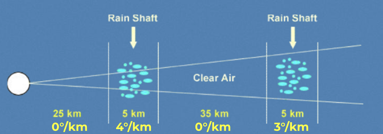
In the above image, the radar beam travels through two areas of rainfall that look similar, but KDP values are different. In the first, the KDP is 4°/km and in the second it’s 3°/km. This means that the radar beam is being slowed down more in the first area of rain compared to the second. With this information, we know that the rainfall is heavier in the first rain shaft. So what does this actually look like?
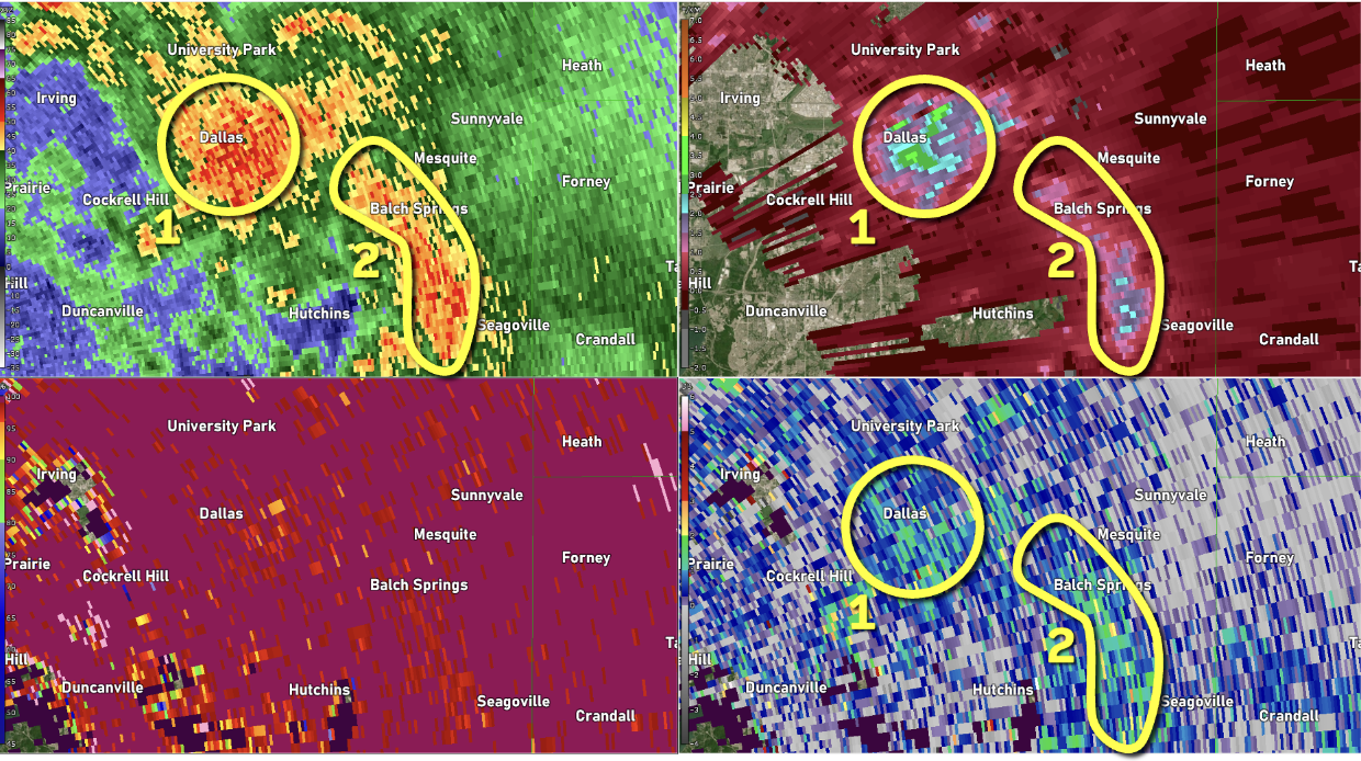
In the above image, there is a cluster of thunderstorms producing very heavy rainfall across Dallas, Texas, shortly after midnight. Two areas of concern are highlighted – one is very near downtown (1) and the other extends across the southeast parts of the city (2). Notice how the base reflectivity (top left) and differential reflectivity (bottom right) is similar in both of these clusters.
When we look at KDP though, there is a noticeable difference between the two areas of rainfall. KDP values in cluster 1 are around 3.1°/km, and in cluster 2 they are around 2.0°/km. This tells us that the radar beam is being slowed more in cluster 1 and therefore the heavier rainfall is located here, despite similar reflectivity values. Significant flash flooding occurred during this time, resulting in one fatality.
Dual polarization products are routinely used in conjunction with Base Reflectivity and Base Velocity to provide more information about the precipitation that the radar is encountering. This is beneficial to meteorologists providing crucial warning information and can help in pinpointing threats to the public.

