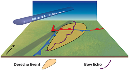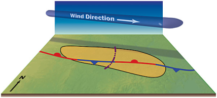

Derechos can be categorized into three main types: serial, progressive, and hybrid. These categories are largely based on the overall organization and behavior of the thunderstorms producing the derecho.
The type of derecho most often encountered during the spring and fall is called a serial derecho. Serial derechos are produced by multiple bow echoes embedded in an extensive squall line (often many hundreds of miles long) that sweeps across a very large area, both wide and long.
This type typically is associated with a strong upper level trough with a strong surface low pressure system.
An example of a serial derecho affected Florida, Cuba, and adjacent parts of the Gulf of Mexico, the Caribbean Sea, and the Atlantic Ocean during the early stages of the "Storm of the Century" on March 12-13, 1993.
The second type of derecho is called a progressive derecho. These are associated with a relatively short line of thunderstorms, typically, 40-250 miles (65-400 kilometers) in length.
Mainly a summertime occurrence, these derechos usually are associated with a stationary front that is parallel to the upper level air flow.
Progressive derechos may travel for many hundreds of miles along a path that is relatively narrow compared to those of serial derechos. An example of this type is the "Boundary Waters-Canadian Derecho" that occurred on July 4-5, 1999.
In other cases, the progressive derecho and associated bow echo system begin relatively small with a narrow path but over time grow to exceed 250 miles (400 kilometers) in width. The line of thunderstorms of a progressive derecho often begins as a single bow echo that evolves into a short squall line, typically with more than one embedded bowing segment.
Such development occurred with the "I-94 Derecho" over the north central United States on July 19, 1983. They are often associated with an area of weak low pressure at the surface.
The third type of derecho is known as a "hybrid" derecho, which have characteristics of both the "progressive" and "serial" types. For example, the "Southern Great Lakes Derecho" of May 30-31, 1998, was associated with a strong migrating low-pressure system. However, the derecho path and the associated bow echo system had many characteristics of a progressive derecho event.
In contrast to most derecho-producing thunderstorm systems which typically occur in association with very moist air, bands of widespread wind-producing storms sometimes occur in environments of very limited moisture.
These systems are referred to as low dew point derechos. A form of serial derecho, they most often occur between late fall and early spring, in association with strong low-pressure systems.


