An air mass is a large body of air with generally uniform temperature and humidity. The area over which an air mass originates is what provides its characteristics. The longer the air mass stays over its source region, the more likely it will acquire the properties of the surface below.
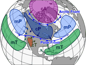
There are two broad overarching divisions of air masses based upon moisture content. Continental air masses, designated by the lowercase letter "c", originate over continents and are therefore dry air masses. Maritime air masses, designated by the letter "m", originate over the oceans and are therefore moist air masses.
Each of the two divisions are then divided based upon the temperature of the surface over which they originate.
- Arctic air masses, designated by the letter "A", originate over the Arctic or Antarctic regions and therefore are very cold.
- Polar air masses, designated by the letter "P", originate over the higher latitudes of both land and sea and are therefore not as cold as Arctic air masses.
- Tropical air masses, designated by the letter "T", originate over the lower latitudes of both land and sea and therefore are warm/hot.
Putting both designations together, we have, for example, a "continental arctic" air mass designated by "cA", which originates over the poles and is therefore very cold and dry. Continental polar (cP) is not as cold as the Arctic air mass but is also very dry. Maritime polar (mP) is also cold but moist due to its origin over the oceans. The desert region air masses (hot and dry) are designated by "cT" for "continental tropical".
As these air masses move around the Earth, they can acquire additional attributes. For example, in winter, an arctic air mass (very cold and dry air) can move over the ocean, picking up some warmth and moisture from the warmer ocean and becoming a maritime polar air mass (mP) – one that is still fairly cold but contains moisture.
If that same polar air mass moves south from Canada into the southern U.S., it will pick up some of the warmth of the ground, but due to lack of moisture, it remains very dry. This is called a continental polar air mass (cP).
Air mass boundaries

Air mass motion is usually based upon the air flow in the upper atmosphere. As the jet stream changes intensity and position, it affects the motion and strength of air masses. Where air masses converge, they form boundaries called "fronts".
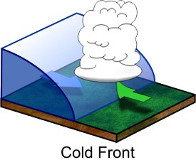
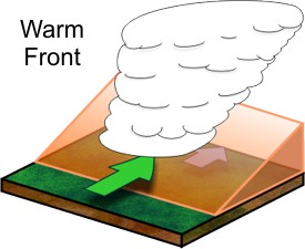
Fronts are identified by a change of temperature based upon their motion. With a cold front, a colder air mass is replacing a warmer air mass. A warm front is the opposite – when warm air replaces cold air. There is also a stationary front, which, as the name implies, means the boundary between two air masses does not move.
The motion of air masses also affects where a good portion of precipitation occurs. The air of cold air masses is more dense than warmer air masses. Therefore, as these cold air masses move, the dense air undercuts the warmer air masses, forcing the warm air up and over the colder air and causing it to rise into the atmosphere.
Therefore, fronts aren’t just at the surface of the Earth; they have a vertical structure or slope to them as well. Warm fronts typically have a gentle slope, so the air rising along the frontal surface is gradual.

With warm fronts, the gentle slope favors a broad area of rising air, so there is typically widespread layered or stratiform cloudiness and precipitation along and to the north of the front. The slope of cold fronts, being much more steep, forces air upward more abruptly. This can lead to a fairly narrow band of showers and thunderstorms along or just ahead of the front.
Another type of boundary divides moist air from dry air. Called a dry line, this boundary will separate moist air from the Gulf of Mexico (to the east) and dry desert air from the southwestern states (to the west). It typically lies north-south across the central and southern high Plains states during the spring and early summer. The dry line typically advances eastward during the afternoon and retreats westward at night.


