Weather maps come in a myriad of styles, each providing different levels of information. However, there are some common features typically found in all of these images.
In the section about the Origin of Wind, we have seen the source of the "highs" and "lows". Boundaries between these air masses are depicted with lines called "fronts".
Fronts are usually detectable at the surface in a number of ways: winds often "converge" or come together at the fronts, temperature differences can be quite noticeable from one side of a front to the other side, and the pressure on either side of a front can vary significantly.
Phrases like "ahead of the front" and "behind of the front" refer to a front’s motion – being "behind the cold front" means being inside the cold air mass, and being "ahead of the cold front" means being in the warm air mass the cold air mass is displacing as it moves.
The terms "cold" and "warm", however, are relative. For example, in summer, a “cold front” might actually have a 90°F (32°C) air mass behind it if the warmer air mass ahead is 95°F (35°C).
Fronts
Cold Front

Cold fronts demarcate the leading edge of a cold air mass that is displacing a warmer air mass. They are depicted by a blue line with triangles pointing in the direction of motion.
Cold fronts nearly always extend south and west of the center of a low pressure area and never from high-pressure systems.
Warm Front

A warm front is the leading edge of a warm air mass that is replacing a colder air mass. A warm front is depicted by a red line with half-moons pointing the direction of its motion.
Like cold fronts, warm fronts also extend from the center of low-pressure areas, but nearly always on their east side.
Here is an example of a typical warm frontal passage followed by a cold frontal passage:
Clouds lower and thicken as the warm front approaches, bringing several hours of light to moderate rain. Temperatures are in the 50s with winds from the east. As the warm front passes, the rain ends, skies become partly cloudy, and temperatures warm into the mid 70s. Winds become gusty from the south. A few hours later, a line of thunderstorms sweeps across the area just ahead of the cold front. After the rain ends and the front passes, winds shift to the northwest, temperatures fall into the 40s, and skies clear.
Stationary Front

A stationary front is one that is not moving (i.e. the two air masses on either side are not moving perpendicular to the front – one is not displacing the other). This is depicted by an alternating red and blue line with triangles on the blue portion pointing away from the cool air mass and half-moons on the opposite side of the red portion of the line, pointing away from the warm front.
A cold or warm front that stops moving becomes a stationary front. The difference in temperature and wind direction between either side of a stationary front is generally not large, but sometimes can be stark.
Occluded Front

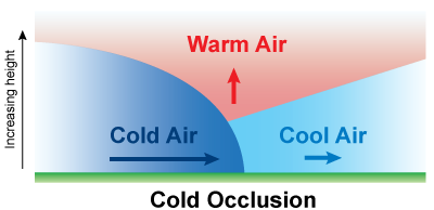
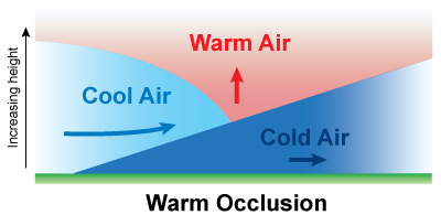
Cold fronts typically move faster than warm fronts, which means they can sometimes "catch up" to warm fronts. As they do, the warm air mass is forced up from behind, forming what is called an occlusion.
The surface location of the occluded front is directly below the convergence point of the warm air mass, the cold air mass undercutting it, and the cooler air mass already ahead of the warm front. Occluded fronts are usually a sign that the parent weather system has reached its mature stage and is decaying (decreasing in intensity). They are indicated by a purple line with alternating triangles and half-moons on the side of its motion.

While there is no difference in how they are depicted on a weather map, there are two types of occlusions: cold and warm.
Cold occlusions are the most common: the cold front overtakes the warm front and also undercuts the cool air mass ahead of it.
Warm occlusions occur when the air behind the "cold" front is actually not as cold as the cool air mass ahead of the warm front. The warm air is forced up as before, but the colder, denser air mass ahead of the warm front remains at the surface, forcing the cold air mass behind the cold front up as well.

Other Boundaries
Dry Line

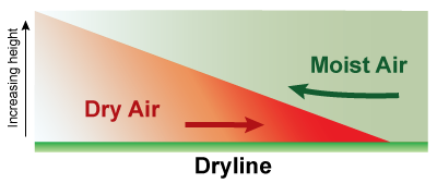
A dry line marks the boundary between a moist air mass and dry air mass. It typically lies north-south across the central and southern high Plains states during the spring and early summer, where it separates moist air from the Gulf of Mexico to the east and dry desert air from the southwestern states.

The dry line typically advances eastward during the afternoon and retreats westward at night. However, a strong storm system can sweep the dry line eastward into the Mississippi Valley, or even further east, regardless of the time of day.
A typical dry line passage results in a sharp drop in humidity, a rise in temperatures, clearing skies, and a wind shift from south or southeasterly to west or southwesterly. Blowing dust and rising temperatures also may follow, especially if the dry line passes during the daytime. These changes occur in reverse order when the dry line retreats westward.
Since drier air is more dense than moist air, the dryline forces moist air up into the atmosphere as it moves east. Therefore, severe and sometimes tornadic thunderstorms can develop along a dry line or in the moist air just to the east of it.
Squall Line

The squall line is a line of thunderstorms that generally form along a front and move ahead of it. As the rain-cooled air under the thunderstorms begins to surge forward, new thunderstorms form on the leading edge of the outflow.
The outflow acts like a cold front with an increase of forward speed and therefore an increase in forward speed of the line of thunderstorms. Squall lines are most notably seen in derechos.
Other Symbols
Trough

A trough is not a boundary but an elongated area of lower air pressure. There are changes in wind direction across a trough, but there is no change in air mass.
While not specifically a surface boundary, troughs reflect the change in atmospheric conditions in the upper atmosphere. As such, troughs can be areas where showers and thunderstorms can form.
Precipitation
Historically, areas of precipitation have been shaded green regardless of type; the type of precipitation can be indicated in numerous ways. Sometimes, the precipitation type is spelled out, but more often it is depicted by a wide variety of graphics and symbols.
Below are some of the more traditional meteorological symbols used on maps to indicate precipitation types.
Rain

Snow

Drizzle

Rain Showers

Snow
Showers

Fog

Thunder-storm

Take it to the MAX! The 'Plot' Thickens


