Wind is simply air in motion. Usually in meteorology, when we are talking about the wind it is the horizontal speed and direction we are concerned about. For example, if you hear a report of a west wind at 15 mph (24 km/h) that means the horizontal winds will be coming FROM the west at that speed.
Although we cannot actually see the air moving we can measure its motion by the force that it applies on objects. We use a wind vane to indicate the wind's direction and an anemometer to measure the wind's speed. But even without those instruments we can determine the direction.
For example, a flag points in the opposite direction of the wind. The wind blows leaves opposite the direction from which the wind is blowing. Airplanes taking off and landing at airports will be into the direction of the wind.
The vertical direction of wind motion is typically very small (except in thunderstorm updrafts) compared to the horizontal component, but is very important for determining the day to day weather. Rising air will cool, often to saturation, and can lead to clouds and precipitation. Sinking air warms causing evaporation of clouds and thus fair weather.

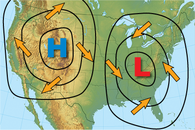
You have probably seen weather maps marked with H's and L's which indicate high- and low-pressure centers. Usually surrounding these "highs" and "lows" are lines called isobars. "Iso" means "equal" and a "bar" is a unit of pressure so an isobar means "equal pressure". So everywhere along each line is the pressure has the same value.
With high-pressure systems, the value of air pressure along each isobar increases toward the center with each concentric line. The opposite is true for low-pressure systems in that with each concentric line toward the center represents lower pressure. Isobars maybe be close together or far apart.
The closer the isobars are drawn together the quicker the air pressure changes. This change in air pressure is called the "pressure gradient". Pressure gradient is just the difference in pressure between high- and low-pressure areas.
The speed of the wind is directly proportional to the pressure gradient meaning that as the change in pressure increases (i.e. pressure gradient increases) the speed of the wind also increases at that location.

Also, notice that the wind direction (yellow arrows) is clockwise around the high-pressure system and counter-clockwise around the low-pressure system. In addition, the direction of the wind is across the isobars slightly, away from the center of the high-pressure system and toward the center of the low-pressure system.
Why does this happen? To understand we need to examine the forces that govern the wind. There are three forces that cause the wind to move as it does. All three forces work together at the same time.
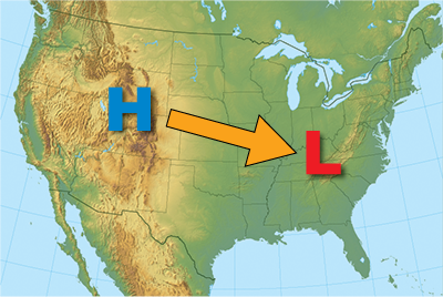
The pressure gradient force (Pgf) is a force that tries to equalize pressure differences. This is the force that causes high pressure to push air toward low pressure. Thus, air would flow from high to low pressure if the pressure gradient force was the only force acting on it.


However, because of the earth's rotation, there is second force, the Coriolis force that affects the direction of wind flow. Named after Gustav-Gaspard Coriolis, the French scientist who described it mathematically in 1835, this force is what causes objects in the northern hemisphere to turn to the right and objects in the southern hemisphere to turn to the left.
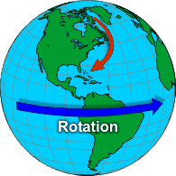
One way to see this force in action is to see what happens when a straight line becomes a curve. Picture the Earth as a turntable (see number 1) spinning counter-clockwise. A ruler is placed over the turntable (see number 2) and a pencil will move in a straight line from the center to the edge while the turntable spins underneath. The result is a curved line on the turntable (see number 3).
When viewed from space, wind travels in a straight line. However, when viewed from the Earth, air (as well as other things in flight such as planes and birds) is deflected to the right in the northern hemisphere (red arrow on image at right). The combination of the two forces would cause the wind to blow parallel to straight isobars with high pressure on the right.
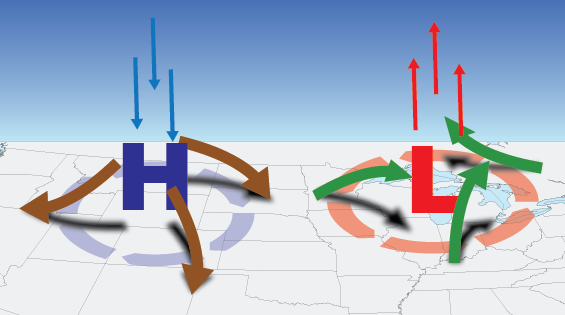
So why does air spiral out from highs and into lows? There is one other force, called friction, which is the final component to determining the flow of wind. The surface of the earth is rough and it not only slows the wind down but it also causes the diverging winds from highs and converging winds near lows.
What happens to the converging winds near a low? A property called mass continuity states that mass cannot be created or destroyed in a given area. So air cannot "pile up" at a given spot.
It has to go somewhere so it is forced to rise. As it rises it cools. When air cools, condensation begins to exceed evaporation so the invisible vapor condenses, forming clouds and then precipitation. That is why there is often inclement weather near low-pressure areas.
What about the diverging air near a high? As the air spreads away from the high, air from above must sink to replace it. Sinking air warms. As air warms, evaporation begins to exceed condensation which means that clouds will tend to evaporate. That is why fair weather is often associated with high pressure.


